Classic
Coast to Coast
Fifty-three years ago, Alfred Wainwright published his Coast to Coast walk, linking St Bees in Cumbria to Robin Hood’s Bay in North Yorkshire. Now formally upgraded to enjoy National Trail status – and set to open in spring 2026 – the route has a timeless appeal, with thousands of walkers each year lacing up their boots to trek almost 200 miles from one side of England to the other
WORDS MARK ROWE

Acorrugated skyline of high Lakeland ridges and peaks radiates westwards from Kidsty Pike, among them High Street, Helvellyn and Scafell Pike. Green curtains, brutal scars and sheer drops fall away, sloping into the frayed ends of drystone walls. I’m in the east of the Lake District and, once I’ve negotiated the small matter of a knee-shaking descent to Haweswater, the bulk of the National Park will be behind me. Just the 10 or so days to go.
I’d begun the Coast to Coast walk in traditional fashion, pocketing a pebble as a companion from below the double headland of St Bees, then passing by Ennerdale and over Helvellyn.
For many, familiar only with the Lake District, the rest of this walk is a step into the unknown. ‘I had known about it for years but, to be honest, I had been thinking: once you’ve left the Lake District, can it really be such a good walk?’ recalls David Johnson of the Wainwright Society. ‘But I loved every stage of it – leaving the Lakes was not an anticlimax.’
He isn’t the only one won over by its charms. The Coast to Coast is being upgraded to a National Trail, and the new route will officially launch in early 2026. The trail will follow a slightly different line in places – see the National Trail website for updates and new maps – but closely follows the much-loved original.
A fortnight on foot
Often imitated, rarely bettered (although Wainwright himself said his was ‘a’ rather than ‘the’ definitive route), the Coast to Coast walk wriggles either side of a beeline between the two coasts, taking in three National Parks, mountains, valleys, rivers, woodland and moorland. Although the route can be walked in either direction, west to east is more popular, mainly because you have the prevailing weather conditions at your back. Wainwright suggests taking 14 days and identifies 13 potential overnight stops. For many walkers, this is pushing it: I ended up taking 15 days.


Walk it
DISTANCE Wainwright’s Coast to Coast walk stretches 309km/192 miles. Two-thirds of the route is inside the National Parks of the Lake District, Yorkshire Dales and North York Moors.
GUIDEBOOKS Wainwright’s original illustrated guide, A Coast to Coast Walk: A Pictorial Guide (Frances Lincoln, ISBN 978 0718140076), can still be found second-hand, but there’s also a fully revised version, updated by Chris Jesty: Wainwright’s Coast to Coast Walk: From St Bees Head to Robin Hood’s Bay (£13.99, Frances Lincoln, ISBN 978 0711239197).
MAPS OS maps OL4, OL5, OL19, OL26, OL27, OL30, 302, 303 and 304.
ACCOMMODATION Macs Adventure offers various packages for walkers, covering the entire route in anything from 14 to 18 days, or the east and west sections separately – eg, Coast to Coast Walk East, for nine days and eight nights, from £1,049pp, including accommodation, baggage transfers, smartphone navigation app and 24/7 emergency support.
FURTHER INFO The Wainwright Society has details of the walk and any access or route issues.
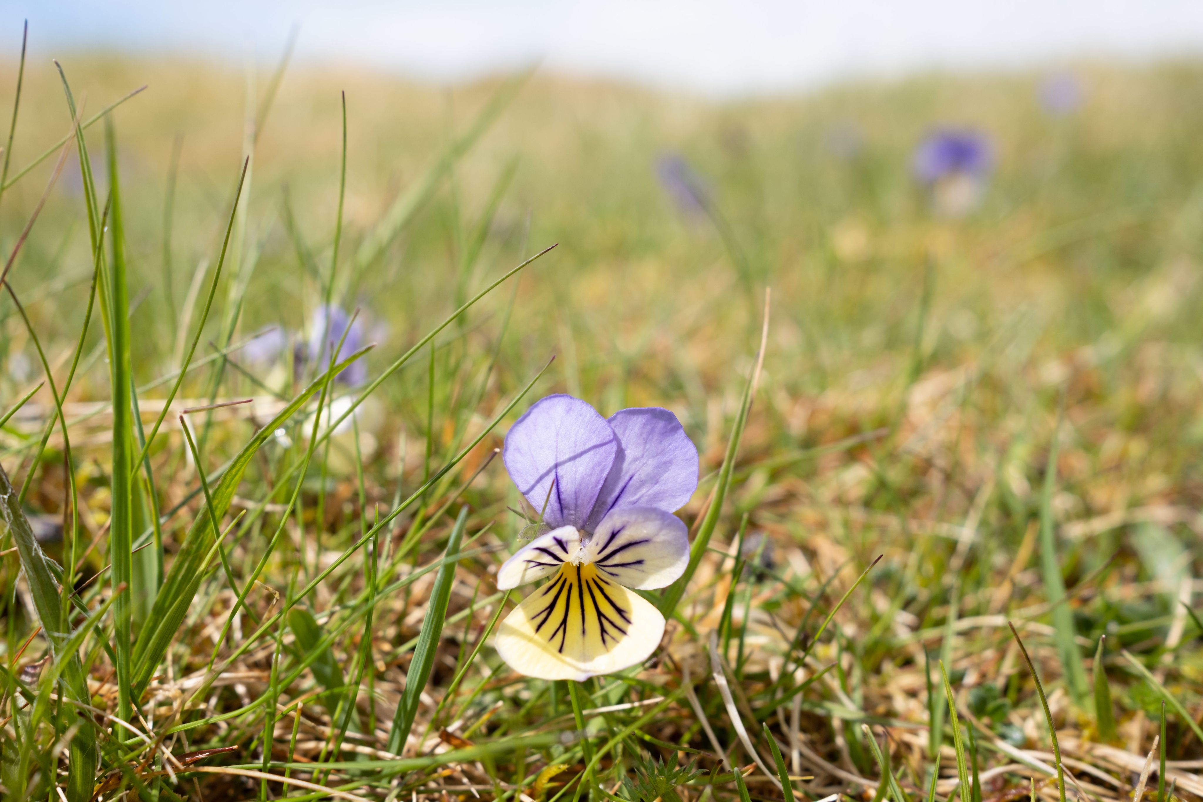
One of the joys of the walk is a sense of stepping from one landscape into another. As I approach Shap, the high Lakeland fells slip away, their hard volcanic and granite rocks replaced by limestone and grassy, farmland-friendly pastures. At Oddendale, this geology emerges out of the ground in the form of limestone pavements. Scattered between these ridges are stone circles, standing stones and erratic boulders deposited by retreating glaciers.
Shap is a short, sharp word that can strike despair into hikers. After leaving the village, there’s no easy opportunity to break the walk for some 32km/20 miles until Kirkby Stephen, a town Wainwright described as ‘a place for licking wounds’. Dead right, though it also has an attractive market cross and the fetching 17th-century Frank’s Bridge across the youthful Carlisle-bound River Eden. If you’re still talking to any companion after this stage, you’re good for the rest of the walk – and probably for life.
Watershed moment
The subsequent day to Keld is little easier. The focal point is Nine Standards Rigg, a plateau-like ridge 662m/2,172ft high, demarcated by an outré collection of nine modern cairns shaped as beehives, pyramids, even a sea stack. These have replaced much older monoliths, their provenance uncertain. A helpful mirador identifies the last view of the Lakes, of Helvellyn and High Street.
Stark and isolated, Nine Standards Rigg is something of a crossroads. Not only do you enter Yorkshire near here, but this is the main watershed of northern England. Until now I’ve been walking, as Wainwright puts it, ‘against the grain’; all the rivers and streams I’ve met have flowed to join the Irish Sea to the west, while beyond they all flow to the North Sea to the east. ‘A quiet celebration on Nine Standards would not be out of place,’ he advises. Fleetingly I imagine Wainwright fist-pumping like a tennis player. The watershed is mesmerising: the bogs and hags here rarely dry out and I eye small puddles as they gently coalesce and bulge, uncertain which way to tilt. Then gravity loses patience with their dithering and sends them, east or west, to the sea.
One of the joys of the walk is a sense of stepping from one landscape into another. As I approach Shap, the high Lakeland fells slip away, their hard volcanic and granite rocks replaced by limestone and grassy, farmland-friendly pastures. At Oddendale, this geology emerges out of the ground in the form of limestone pavements. Scattered between these ridges are stone circles, standing stones and erratic boulders deposited by retreating glaciers.
Shap is a short, sharp word that can strike despair into hikers. After leaving the village, there’s no easy opportunity to break the walk for some 32km/20 miles until Kirkby Stephen, a town Wainwright described as ‘a place for licking wounds’. Dead right, though it also has an attractive market cross and the fetching 17th-century Frank’s Bridge across the youthful Carlisle-bound River Eden. If you’re still talking to any companion after this stage, you’re good for the rest of the walk – and probably for life.
Watershed moment
The subsequent day to Keld is little easier. The focal point is Nine Standards Rigg, a plateau-like ridge 662m/2,172ft high, demarcated by an outré collection of nine modern cairns shaped as beehives, pyramids, even a sea stack. These have replaced much older monoliths, their provenance uncertain. A helpful mirador identifies the last view of the Lakes, of Helvellyn and High Street.


Stark and isolated, Nine Standards Rigg is something of a crossroads. Not only do you enter Yorkshire near here, but this is the main watershed of northern England. Until now I’ve been walking, as Wainwright puts it, ‘against the grain’; all the rivers and streams I’ve met have flowed to join the Irish Sea to the west, while beyond they all flow to the North Sea to the east. ‘A quiet celebration on Nine Standards would not be out of place,’ he advises. Fleetingly I imagine Wainwright fist-pumping like a tennis player. The watershed is mesmerising: the bogs and hags here rarely dry out and I eye small puddles as they gently coalesce and bulge, uncertain which way to tilt. Then gravity loses patience with their dithering and sends them, east or west, to the sea.


St Bees Lighthouse
St Bees Lighthouse

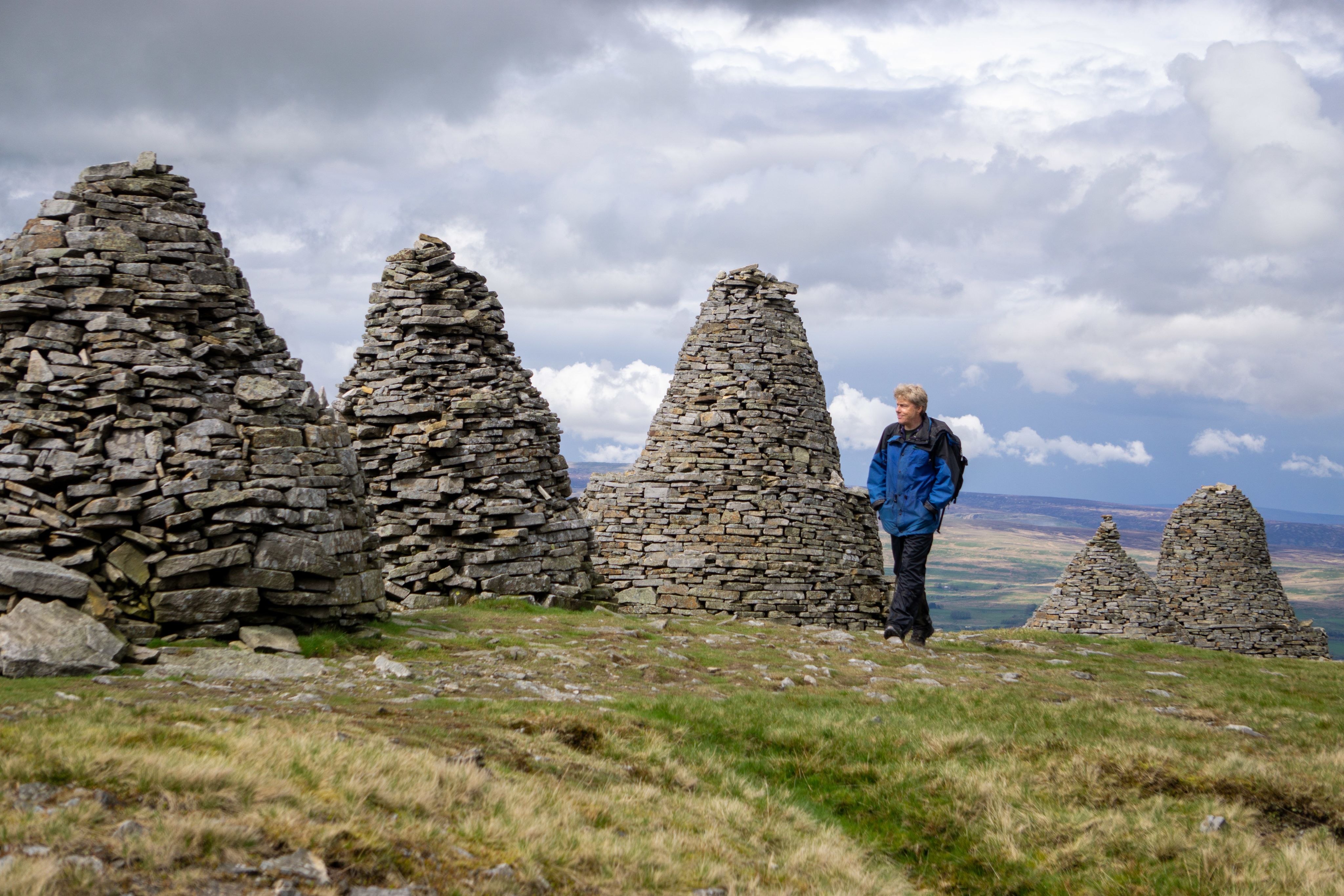
Nine Standards Rigg
Nine Standards Rigg

Haweswater
Haweswater


Keld basks in Wainwright’s unstinting approval, described as ‘a real hamlet, an outpost in the wild’. Walkers tend to like it too as it more or less marks the route’s halfway point. Changes in geology – from sandstone to gritstone to limestone – are reflected along the trail, not just in landscape but also in buildings. And Keld, hewn from the natural edges above the infant River Swale, is made almost entirely of local slate. Birdlife is another marker, with the cormorants of St Bees and the ravens and stonechats of Kidsty Pike long replaced by lapwings and oystercatchers in the moorlands, and dippers along the rivers. Skylarks are regular companions; gulls are constant. The route briefly intertwines with the Pennine Way and meanders through the disused lead mines above the Swale in what Wainwright called ‘a graphic scene of industrial decay’.
From riverside to railway
The North York Moors prove easy to love, their gullies and ascents enjoyed rather than endured. The River Esk dissects the high moors, watering an absurdly idyllic pocket of woodland at Glaisdale. I cross the Esk via Beggar’s Bridge, a high-arch packhorse sandstone gem.
The final day begins in Grosmont, where my first impression is that I have stepped back in time, beyond even 1973, to the puff-puff heyday of steam travel. The station lies on the vintage North Yorkshire Moors Railway line and my rambles coincide with the arrival of a locomotive, pistons pumping, smoke billowing. After so many days, during which my attire and appearance have been gently shredded, the neatly pressed orange livery of the station and prim, just-so bedding plants seem surreal.


Railway at Grosmont
Railway at Grosmont
Reality returns as I slog uphill back onto the moors. The first view of the east coast is due to emerge on Sleights Moor, but I’m thwarted by a creeping mist, settled at hip height and not for budging.
Progress on the trail
A busy road crossing in this miasma makes me grateful for the overbridges and other enhancements that will come to the route with National Trail status (officially pencilled in for spring 2026) to reflect heavier traffic on what were once lightly used roads. While 85% of the existing route is a public right of way or on land with existing legal access rights, Natural England – after consultation with Ramblers groups – plans nearly 16km/10 miles of new public footpath and 14.5km/9 miles of new public bridleway, as well as circular paths to make the trail more accessible for those seeking shorter walks. The route will be plotted by Ordnance Survey on its next edition of maps and waymarked in its entirety (currently, the route is essentially a collection of footpaths in a guidebook).
The murky ceiling lifts only when I exchange the high moor for the woodlands cloaking the hamlet of Littlebeck. Alders dip their fingers in the mesh of streams that rub shoulders and tumble in a succession of waterfalls that climax at Falling Foss, where the water sloshes 9m/30ft to a shallow pool.
Keld basks in Wainwright’s unstinting approval, described as ‘a real hamlet, an outpost in the wild’. Walkers tend to like it too as it more or less marks the route’s halfway point. Changes in geology – from sandstone to gritstone to limestone – are reflected along the trail, not just in landscape but also in buildings. And Keld, hewn from the natural edges above the infant River Swale, is made almost entirely of local slate. Birdlife is another marker, with the cormorants of St Bees and the ravens and stonechats of Kidsty Pike long replaced by lapwings and oystercatchers in the moorlands, and dippers along the rivers. Skylarks are regular companions; gulls are constant. The route briefly intertwines with the Pennine Way and meanders through the disused lead mines above the Swale in what Wainwright called ‘a graphic scene of industrial decay’.

From riverside to railway
The North York Moors prove easy to love, their gullies and ascents enjoyed rather than endured. The River Esk dissects the high moors, watering an absurdly idyllic pocket of woodland at Glaisdale. I cross the Esk via Beggar’s Bridge, a high-arch packhorse sandstone gem.
The final day begins in Grosmont, where my first impression is that I have stepped back in time, beyond even 1973, to the puff-puff heyday of steam travel. The station lies on the vintage North Yorkshire Moors Railway line and my rambles coincide with the arrival of a locomotive, pistons pumping, smoke billowing. After so many days, during which my attire and appearance have been gently shredded, the neatly pressed orange livery of the station and prim, just-so bedding plants seem surreal.
Railway at Grosmont
Railway at Grosmont
Reality returns as I slog uphill back onto the moors. The first view of the east coast is due to emerge on Sleights Moor, but I’m thwarted by a creeping mist, settled at hip height and not for budging.
Progress on the trail
A busy road crossing in this miasma makes me grateful for the overbridges and other enhancements that will come to the route with National Trail status (officially pencilled in for spring 2026) to reflect heavier traffic on what were once lightly used roads. While 85% of the existing route is a public right of way or on land with existing legal access rights, Natural England – after consultation with Ramblers groups – plans nearly 16km/10 miles of new public footpath and 14.5km/9 miles of new public bridleway, as well as circular paths to make the trail more accessible for those seeking shorter walks. The route will be plotted by Ordnance Survey on its next edition of maps and waymarked in its entirety (currently, the route is essentially a collection of footpaths in a guidebook).
The murky ceiling lifts only when I exchange the high moor for the woodlands cloaking the hamlet of Littlebeck. Alders dip their fingers in the mesh of streams that rub shoulders and tumble in a succession of waterfalls that climax at Falling Foss, where the water sloshes 9m/30ft to a shallow pool.

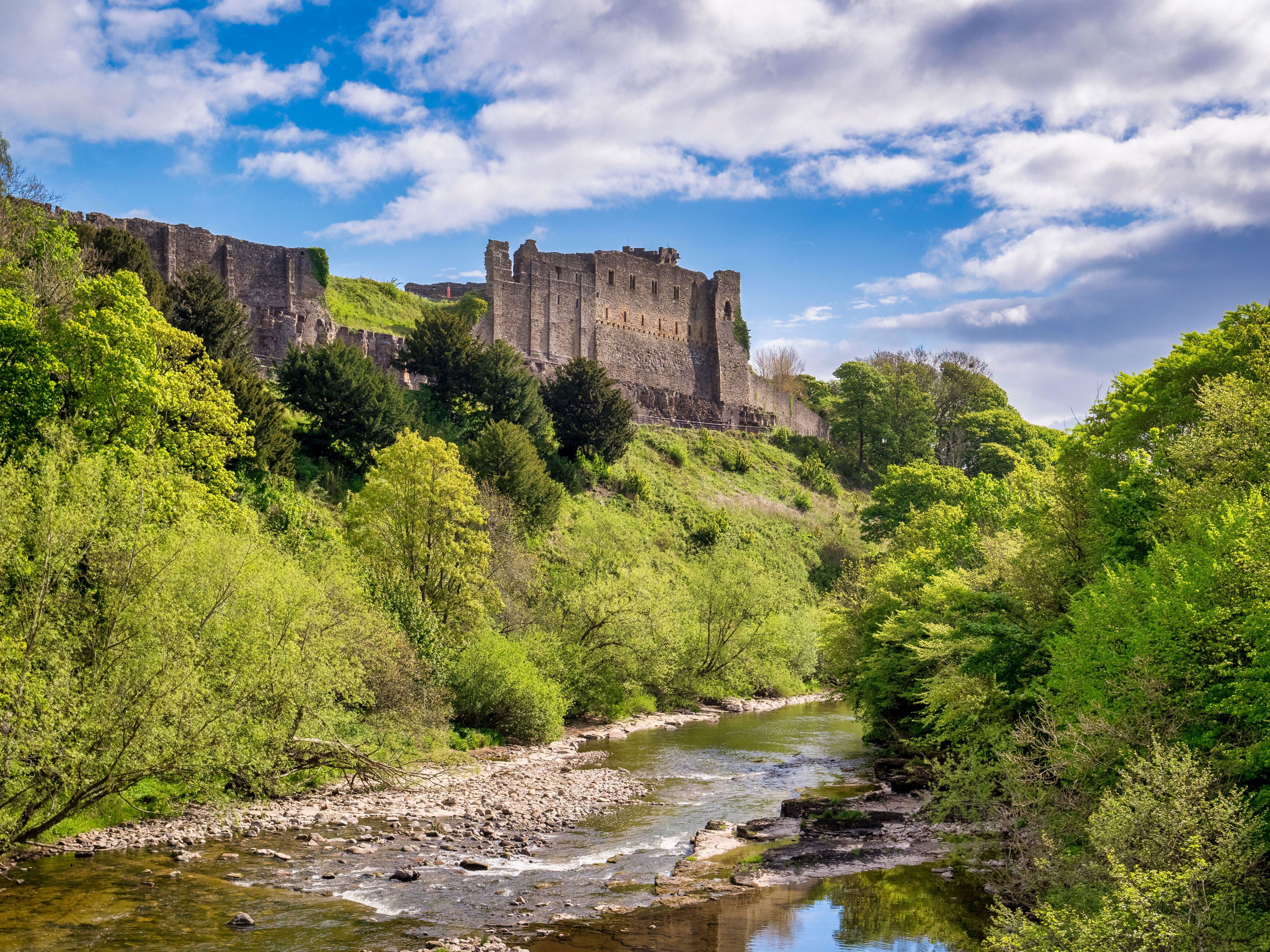
Richmond Castle
Richmond Castle
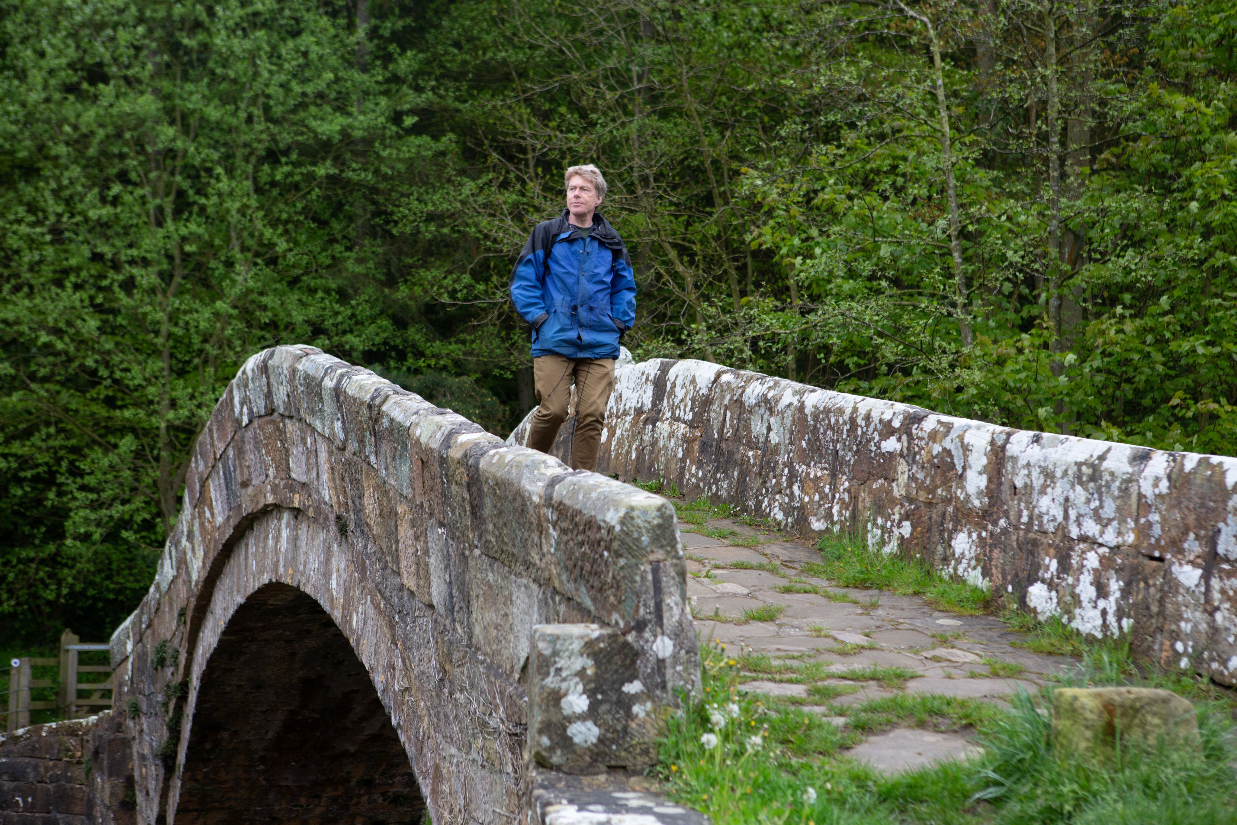
Beggar's Bridge
Beggar's Bridge
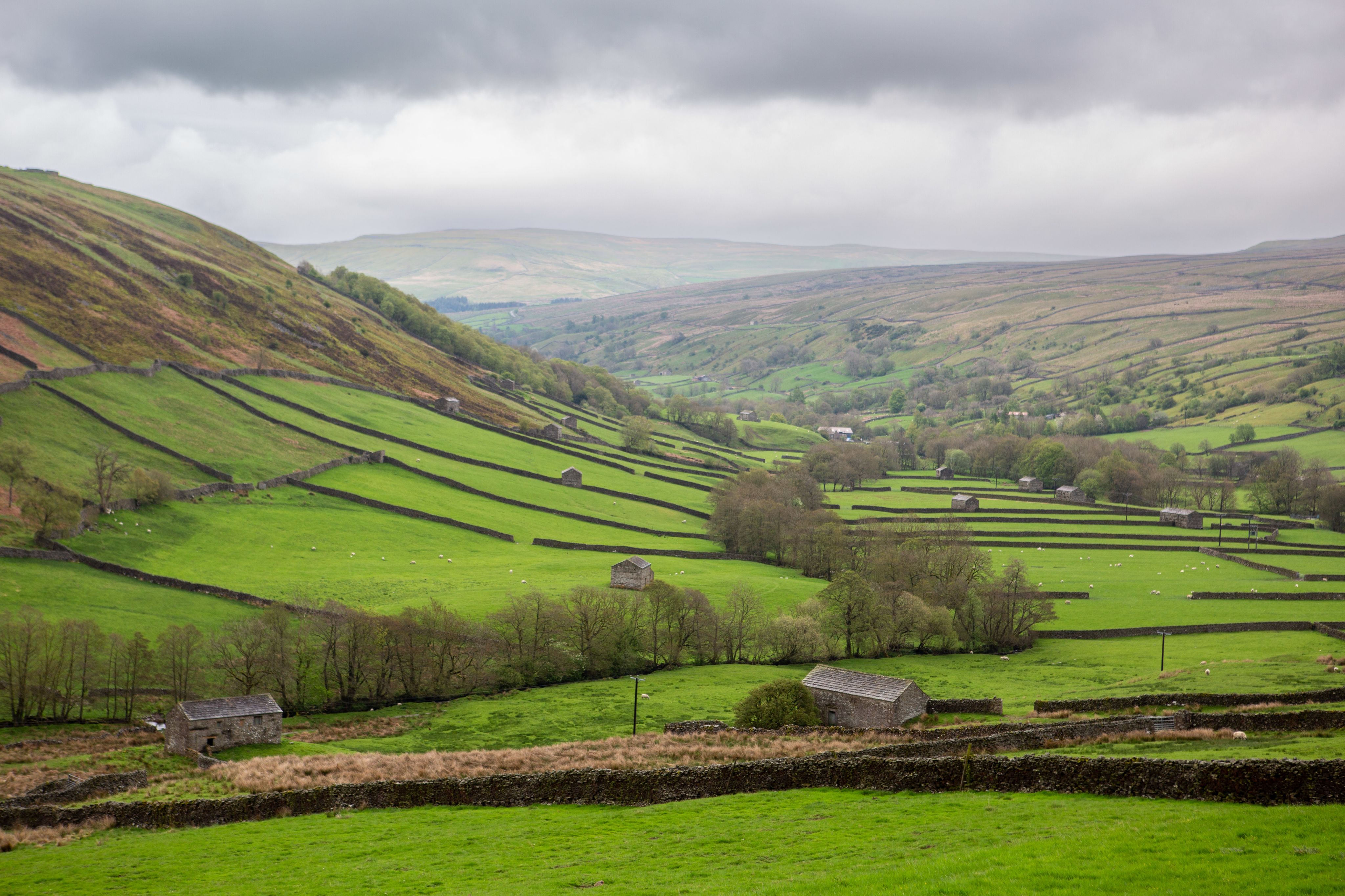
Swaledale
Swaledale
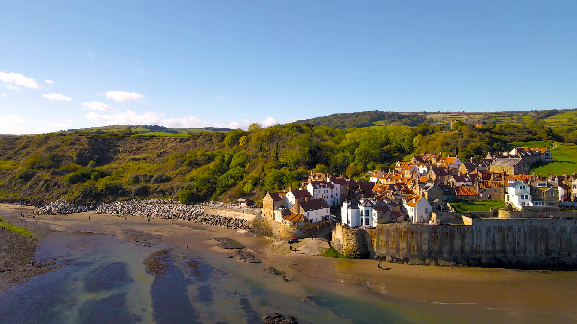
I squelch my way across one final stretch of moorland towards the coast. A fingerpost sign indicates just 3.2km/2 miles to Robin Hood’s Bay, but the chequered flag is not yet in sight because Wainwright flicks his route to the northeast to give walkers a valedictory 5km/3-mile sojourn down the coast via 18th-century Jackass Trods, named for the donkeys that toiled to bring coal up from the coast. Humans have it easier: the Cleveland Way gently undulates between farmland and the sea, which is busily gouging out huge bowls from the liminal soft clays. As tradition dictates, I drop the sandstone pebble from St Bees into the water and look up at the wave-shaped sea defences that prop up the pubs and houses of Robin Hood’s Bay. At St Bees Head, the west coast is defiant, jutting its chin into the Irish Sea. The east coast simply buckles in the face of the elements.
Plus ça change
Little has changed, yet much has changed, in the 50 years since Wainwright wrote his guide. The gruelling nature of the peat-plodding seems eternal, the ravines of the Lakes remain unforgiving and some places are mobile-phone blackspots. Good judgement, despite technology, is still relevant. Climate change is palpably shaping matters along the route, from seawater inundation to greater rainfall running off the fells and moors into villages and towns. Wainwright’s pen-and-ink drawings remain accurate to this day, but would now have to include wind farms in many backgrounds. The language of his book is oriented towards the male walker; he would likely be taken aback by the number of female hikers who also ply the route.

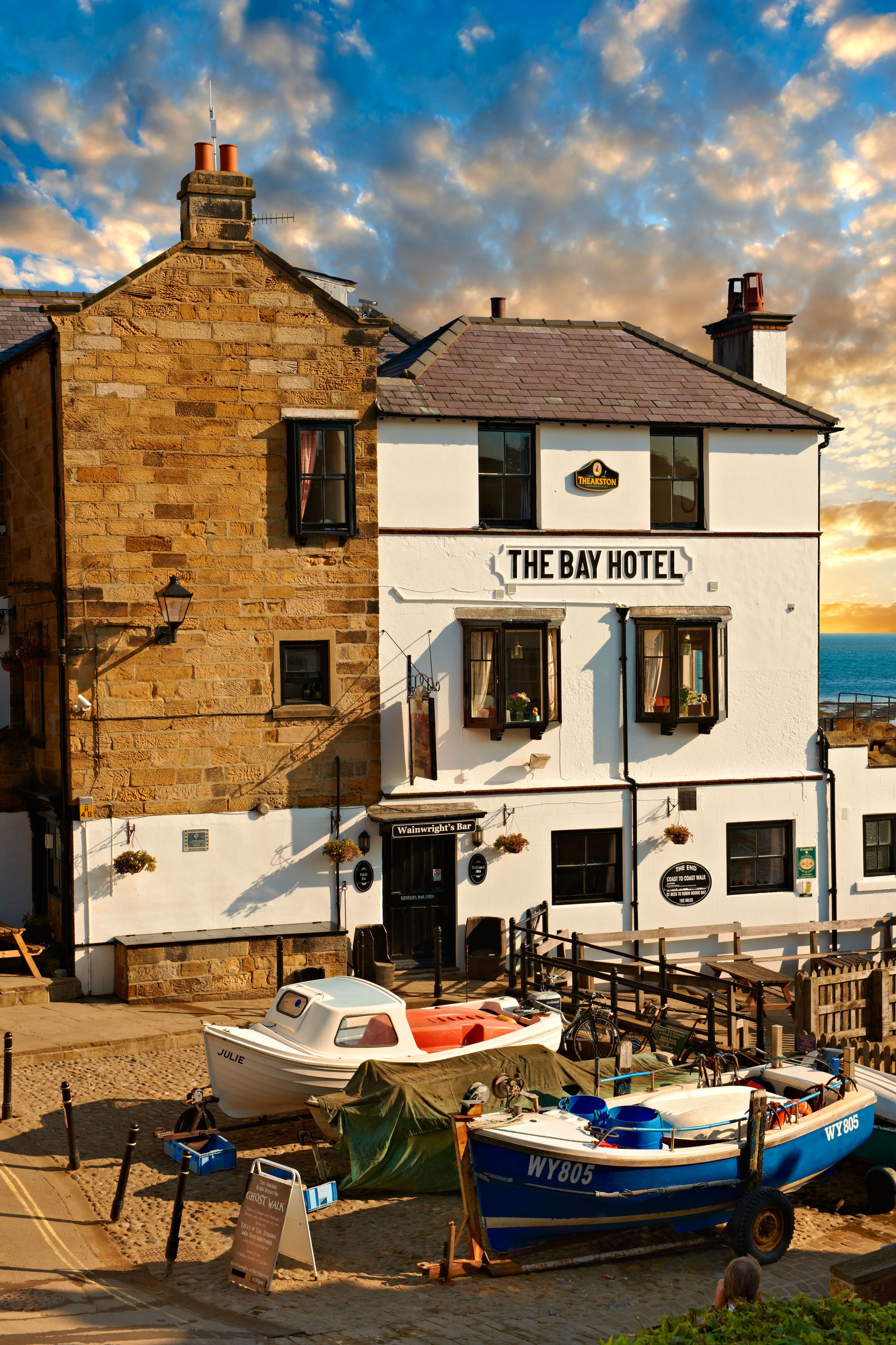
The Bay Hotel
The Bay Hotel
Wainwright finished the Coast to Coast walk, he wrote, with ‘regret’. You may feel the same, not least because it is a sociable walk. Solitary days are rare and you often overtake, are overtaken by, or fall in with people. Most stop to chew the cud, including those headed west. There’s nothing to stop you turning around and following them. Except, perhaps, for a drink with your name on it at The Bay Hotel in Robin Hood’s Bay, where a sign marks the end of the route.


I squelch my way across one final stretch of moorland towards the coast. A fingerpost sign indicates just 3.2km/2 miles to Robin Hood’s Bay, but the chequered flag is not yet in sight because Wainwright flicks his route to the northeast to give walkers a valedictory 5km/3-mile sojourn down the coast via 18th-century Jackass Trods, named for the donkeys that toiled to bring coal up from the coast. Humans have it easier: the Cleveland Way gently undulates between farmland and the sea, which is busily gouging out huge bowls from the liminal soft clays. As tradition dictates, I drop the sandstone pebble from St Bees into the water and look up at the wave-shaped sea defences that prop up the pubs and houses of Robin Hood’s Bay. At St Bees Head, the west coast is defiant, jutting its chin into the Irish Sea. The east coast simply buckles in the face of the elements.
Plus ça change
Little has changed, yet much has changed, in the 50 years since Wainwright wrote his guide. The gruelling nature of the peat-plodding seems eternal, the ravines of the Lakes remain unforgiving and some places are mobile-phone blackspots. Good judgement, despite technology, is still relevant. Climate change is palpably shaping matters along the route, from seawater inundation to greater rainfall running off the fells and moors into villages and towns. Wainwright’s pen-and-ink drawings remain accurate to this day, but would now have to include wind farms in many backgrounds. The language of his book is oriented towards the male walker; he would likely be taken aback by the number of female hikers who also ply the route.
The Bay Hotel
The Bay Hotel
Wainwright finished the Coast to Coast walk, he wrote, with ‘regret’. You may feel the same, not least because it is a sociable walk. Solitary days are rare and you often overtake, are overtaken by, or fall in with people. Most stop to chew the cud, including those headed west. There’s nothing to stop you turning around and following them. Except, perhaps, for a drink with your name on it at The Bay Hotel in Robin Hood’s Bay, where a sign marks the end of the route.

We are the Ramblers, Britain’s walking charity. We open the way for everyone to enjoy the simple pleasures of walking. And we step up to protect the places we all love to wander. Click to find out more.

The Ramblers’ Association is a company limited by guarantee, registered in England and Wales. Company registration no. 4458492. Registered charity, England & Wales no. 1093577, Scotland no. SCO39799.
© Ramblers 2026